A White Paper on Melting the Ice, Finding the Water,
and the Slow Return of a Planet’s Hydrological Cycle
———————————————
Subsurface Ice Inventories, Thermal Extraction, Phase Diagram Constraints,
and the First Liquid Water on the Surface of Mars Since the Hesperian
Abstract
This paper examines the fifth stage of the Mars Habitat Project’s ten-stage terraforming framework: the liberation of water from Mars’s vast frozen reserves. Stage 5 is a direct consequence of Stage 4 — as atmospheric pressure and temperature rise from engineered warming, subsurface ice that has been locked in the Martian crust for billions of years begins to melt.
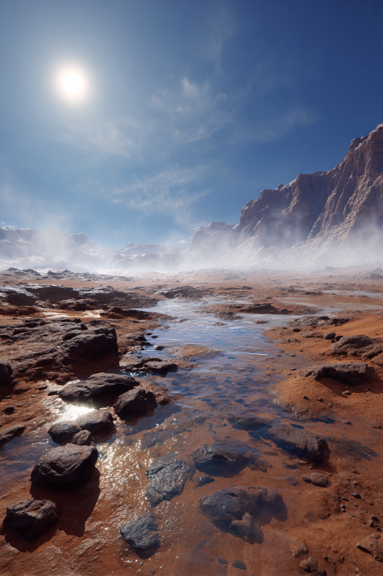
Water appears first as moisture seeping through warmed regolith, then as seasonal pooling in low-lying basins, then as persistent surface water in the deepest and warmest locations. This transition is not instantaneous. It is governed by the physics of the water phase diagram, the depth and distribution of buried ice, the non-uniform warming pattern produced by Stage 4, and the geological reality that Mars’s water inventory — though enormous — is buried at varying depths and locked in varying states.
This paper maps the known water ice reserves (more than five million cubic kilometers detected at or near the surface, with potentially ocean-scale volumes in the deep crust), evaluates the thermodynamic conditions under which that ice transitions to liquid water, identifies the locations where liquid water will appear first (Hellas Basin, Utopia Planitia, Argyre), describes methods for accelerating ice liberation through targeted engineering, and explains how the emerging water cycle connects to Stage 6’s outdoor biological test zones and the longer arc of making Mars habitable. Throughout, the greenhouses of Stage 3 continue operating — and the atmospheric engineering of Stage 4 continues running — because water liberation is not a replacement for those efforts but their consequence.
1. Introduction
1.1 What Stage 4 Made Possible
Stage 4 of this framework describes the deliberate warming of Mars through super greenhouse gases, engineered nanoparticle aerosols, and the positive feedback loop by which warming releases frozen CO₂, which traps more heat, which drives further warming. By the time Stage 5 becomes operative, that process has achieved its primary objective: a significantly thicker, warmer Martian atmosphere. Surface pressure has approximately doubled from the sublimation of the south polar CO₂ deposit. Mean surface temperatures have risen by tens of kelvin. The atmosphere, while still predominantly CO₂ and still far from breathable, is thick enough and warm enough that a threshold has been crossed: in certain locations, at certain times, water ice can melt instead of sublimating directly to vapor.
This is the threshold that separates Stage 4 from Stage 5. Stage 4 changed the sky. Stage 5 is about what happens on the ground when the sky changes. Ice that has been frozen for billions of years begins responding to conditions it has not experienced since the Hesperian period, roughly three billion years ago, when rivers carved channels across the Martian surface and lakes filled impact basins. The water did not leave Mars. It went underground, locked into the regolith as permafrost, buried under debris as glaciers, trapped in polar layered deposits, and — as seismic data from the InSight mission now suggests — sequestered as liquid in fractured rock kilometers below the surface. Stage 5 begins bringing that water back.
1.2 What Water Liberation Means
Water liberation on Mars is not the act of turning on a faucet. It is the managed and monitored process by which rising temperatures and pressures cause phase transitions in the planet’s enormous ice reserves. In some locations, this will happen passively — warmed regolith releases moisture that migrates toward the surface, condenses, and pools. In other locations, particularly ice-rich regions identified during Stage 1 reconnaissance, engineers will accelerate the process through targeted thermal extraction: drilling into buried ice deposits, applying heat, and collecting or directing the resulting meltwater. In still other locations, the process will take centuries, because the ice is too deep, too cold, or too insulated to respond quickly to surface warming.
The goal of Stage 5 is not to flood Mars. It is to establish the conditions under which a hydrological cycle — evaporation, atmospheric transport, condensation, precipitation, surface flow, infiltration — can begin to function. This cycle operated on early Mars. The evidence is written in the planet’s geology: valley networks, paleolake beds, deltaic deposits, hydrated minerals. Stage 5 seeks to restart what Mars’s climate once sustained, using the atmospheric conditions that Stage 4 has rebuilt and the ice reserves that the planet retained throughout its long, cold interregnum.
1.3 Scope of This Paper
This paper is organized in eight sections. First, a comprehensive inventory of Mars’s known water ice reserves — polar, mid-latitude, equatorial, and deep crustal. Second, the phase diagram constraints that govern when and where ice becomes liquid water. Third, the locations where liquid water will appear first. Fourth, methods for accelerating water liberation through engineering. Fifth, the formation of a nascent water cycle. Sixth, the relationship between water liberation and perchlorate remediation. Seventh, how Stage 3 greenhouses and Stage 4 atmospheric engineering continue throughout Stage 5. Eighth, how water liberation enables Stage 6 and subsequent stages.
2. The Water Inventory: What Mars Has Preserved
Mars is not a dry planet. It is a frozen planet. The distinction matters enormously for Stage 5: if Mars were truly dry, water liberation would require importing water from comets or outer solar system moons. Instead, Mars possesses an immense water inventory locked in ice at and below the surface, in polar caps, in mid-latitude glaciers, in regolith permafrost, and in deep crustal reservoirs. The challenge is not finding water — it is accessing it.
2.1 Polar Ice Caps
The north polar cap (Planum Boreum) contains approximately 1.6 million cubic kilometers of water ice, equivalent to roughly half the volume of the Greenland ice sheet. It consists of layered deposits of water ice interbedded with dust, extending to a depth of approximately 3 kilometers. The south polar cap (Planum Australe) is smaller in water ice volume but overlies the massive CO₂ deposit discussed in the Stage 4 white paper. As Stage 4 warming sublimated much of the south polar CO₂, the underlying water ice layers become increasingly exposed and accessible. Together, the polar caps represent the single largest confirmed water ice reservoir on Mars, with a combined volume sufficient to cover the entire planetary surface to a depth of approximately 20 meters if melted.
However, the polar caps present a geographic challenge: they are located at high latitudes where, even after Stage 4 warming, temperatures remain among the lowest on the planet. Polar ice will be among the last to melt under passive warming conditions. Active engineering approaches — orbital mirrors directing concentrated sunlight onto polar ice, or thermal drilling operations — could accelerate the process, but the bulk of Stage 5’s early water liberation will come from lower-latitude ice deposits that warm more quickly.
2.2 Mid-Latitude Subsurface Ice
Between approximately 30° and 60° latitude in both hemispheres, Mars harbors extensive subsurface ice deposits. These take multiple forms: debris-covered glaciers (lobate debris aprons) that flow slowly under their own weight, ice-cemented regolith where pore spaces are filled with frozen water, and massive ice sheets buried beneath thin layers of soil and rock. The Mars Subsurface Water Ice Mapping (SWIM) project, using integrated orbital datasets from radar sounders, neutron spectrometers, thermal instruments, and geomorphic mapping, has produced the most comprehensive maps of this buried ice.
SWIM’s ice consistency maps identify two regions of particular significance: Arcadia Planitia and Deuteronilus Mensae. In Arcadia Planitia, radar data from SHARAD indicate extensive subsurface ice deposits at shallow depths, in some cases within one to five meters of the surface. These deposits extend equatorward of the currently predicted ice stability zone, meaning they are relics of a past climate when conditions allowed ice to accumulate at lower latitudes. Deuteronilus Mensae contains networks of glacier-like forms — lobate debris aprons hundreds of meters thick — that radar analysis confirms are composed of nearly pure water ice beneath a thin debris mantle. Fresh impact craters that excavate into these deposits reveal clean, bright ice at depths as shallow as one meter, confirming the presence of substantial water ice at accessible depths across broad swaths of the mid-latitudes.
The 2025 update to the SWIM project refined mapping to include periglacial landforms — thermal contraction polygons, fractured mounds, and brain terrain — as additional indicators of shallow ice. The updated maps show that the most equatorward excursions of shallow ice occur below 30° latitude, locations thought to be out of equilibrium with the current climate and therefore particularly vulnerable to melting as Stage 4 warming progresses. Total mid-latitude subsurface ice volume remains imprecisely known, but estimates suggest it represents a significant fraction of the more than five million cubic kilometers of ice detected at or near the Martian surface.
2.3 Equatorial Ice: The Medusae Fossae Formation
In 2024, new radar data from Mars Express’s MARSIS instrument revealed what may be the largest water ice deposit in the equatorial region of Mars. The Medusae Fossae Formation (MFF), a wind-sculpted geological feature straddling the highland-lowland boundary near the equator, had been studied since 2007 but its composition remained uncertain. The new analysis by Watters and colleagues, published in Geophysical Research Letters, found that MFF deposits extend up to 3.7 kilometers below the surface and exhibit radar properties consistent with layered ice deposits similar to those in the polar caps. Modeling of compaction behavior showed that no ice-free material could reproduce the observed low density of these deep deposits — only pore-filling ice explains the data.
If confirmed as water ice, the MFF deposits contain a volume estimated at 220,000 to 400,000 cubic kilometers — enough to cover the entire planet in 1.5 to 2.7 meters of water if melted. This would represent the most substantial low-latitude ice deposit on Mars. However, the ice is buried beneath 300 to 600 meters of dry sediment (likely volcanic ash and dust), making it inaccessible to near-term extraction. For Stage 5 purposes, the MFF represents a long-term resource: as warming penetrates deeper into the subsurface over decades and centuries, this equatorial ice becomes increasingly available. Its proximity to the equator, where Stage 4 warming is strongest, makes it a potentially critical late-stage contributor to water liberation.
2.4 Deep Crustal Water: The InSight Discovery
In 2024, Wright, Morzfeld, and Manga published a landmark study in the Proceedings of the National Academy of Sciences analyzing seismic data from NASA’s InSight lander. Using rock physics models and Bayesian inversion — the same mathematical frameworks used on Earth to map underground aquifers and oil fields — they concluded that the Martian mid-crust, at depths of 11.5 to 20 kilometers, contains a layer of fractured igneous rock saturated with liquid water. If representative of the planet as a whole, this reservoir contains enough water to cover Mars’s entire surface to a depth of 1 to 2 kilometers.
A 2025 follow-up study by Sun, Tkalčić, and colleagues in National Science Review identified a complementary low-velocity layer at shallower depths, between 5.4 and 8 kilometers below the surface, interpreted as a high-porosity, water-saturated zone. This study estimated a liquid water volume equivalent to a global ocean 520 to 780 meters deep. Temperature profiles beneath the InSight landing site show that below approximately 5 kilometers, crustal temperatures rise above the freezing point of water, permitting stable liquid water at depth.
These deep reservoirs represent the largest single water inventory on Mars, dwarfing the polar caps and surface ice deposits combined. However, they are also the least accessible. Drilling to depths of 5 to 20 kilometers exceeds current terrestrial capabilities in most geological settings, let alone on Mars. For Stage 5 planning, deep crustal water is a background reality rather than a near-term resource: it confirms that Mars retained the vast majority of its ancient water, but accessing it at scale requires engineering capabilities that lie beyond the Stage 5 timeframe. The deep water is the planet’s savings account — enormous, confirmed, but not easily withdrawn.
2.5 Near-Surface Brines
A 2025 study published in Nature Communications analyzing seasonal variations in marsquake activity detected by InSight revealed evidence of near-surface brines — liquid water with dissolved salts — at meter-scale depths in the northern hemisphere above approximately 30°N. The study found that marsquakes ceased during colder periods and resumed abruptly in warmer seasons, a pattern consistent with ice-to-brine phase transitions: seasonal melting of subsurface ice elevates pore pressure, lubricates faults, reduces frictional strength, and triggers seismic events.
This finding is significant for Stage 5 because it demonstrates that liquid water already exists transiently on Mars under current conditions, albeit as salty brine at shallow depths. Perchlorate salts, which are widespread in Martian soil, depress the freezing point of water to as low as -70°C for calcium perchlorate solutions, enabling liquid water at temperatures far below the melting point of pure water. As Stage 4 warming raises soil temperatures across the planet, the extent and duration of these briny liquid water episodes will increase. Brines are not potable water — perchlorates are toxic to humans — but they represent the leading edge of water liberation: the first liquid water on the warming planet, appearing before pure ice melt becomes widespread.
2.6 Atmospheric Water Vapor
Mars’s current atmosphere contains a small but measurable amount of water vapor, equivalent to a precipitable water column of approximately 10 to 100 micrometers depending on season and latitude. As Stage 4 warming raises surface temperatures, sublimation of exposed ice and evaporation from emerging brines will increase atmospheric water vapor content substantially. This water vapor serves double duty: it is itself a greenhouse gas that amplifies warming (the water vapor feedback loop described in the Stage 4 paper), and it is the atmospheric reservoir from which precipitation can eventually form as the nascent water cycle develops.
3. The Phase Diagram: When Ice Becomes Water
3.1 The Triple Point Constraint
The behavior of water on Mars is governed by its phase diagram — the relationship between temperature, pressure, and the state of water as solid, liquid, or gas. The triple point of water occurs at 611.73 pascals and 0.01°C: below this pressure, liquid water cannot exist regardless of temperature. Ice heated below the triple point pressure sublimes directly to vapor, bypassing the liquid phase entirely. This is why, under current Martian conditions (average surface pressure approximately 610 Pa), water ice on Mars sublimes rather than melts when warmed by sunlight. The Martian surface pressure hovers almost exactly at the triple point — close enough that transient liquid water is marginally possible in the deepest basins during the warmest hours, but not stable in any meaningful sense.
Stage 4’s atmospheric thickening changes this equation fundamentally. Doubling the atmospheric pressure to approximately 1,220 pascals moves the entire planet above the triple point. At this pressure, water ice heated above 0°C can melt to liquid rather than sublime. The liquid water produced is still precarious — at 1,220 pascals and modest temperatures, the water is close to boiling, and evaporation rates are high — but it can persist, pool, and flow in ways that are impossible under current conditions. Further pressure increases from continued atmospheric engineering push Mars deeper into the liquid water stability regime, making surface water increasingly persistent and geographically widespread.
3.2 The Boiling Point Problem
On Earth at sea level (101,325 Pa), water boils at 100°C. On Mars at the doubled pressure of approximately 1,220 pascals, water boils at approximately 10°C. This means that even after Stage 4 warming, liquid water on the Martian surface exists in a narrow temperature band between 0°C (the melting point of pure water) and roughly 10°C (the boiling point at 1,220 Pa). Water warmed above this temperature boils away. This narrow stability window means that the first surface water will appear in locations where temperatures fluctuate within this range — warm enough to melt ice but not so warm that the resulting liquid immediately boils.
As atmospheric pressure continues to increase through ongoing Stage 4 engineering and continued CO₂ sublimation, the boiling point rises. At 5,000 pascals (50 mbar), water boils at approximately 33°C. At 10,000 pascals (100 mbar), the boiling point exceeds 45°C. Each increment of atmospheric pressure widens the temperature window for stable liquid water, making surface water more persistent and geographically extensive. This is why Stage 4 and Stage 5 run concurrently: the atmospheric engineering that continues during water liberation directly improves the conditions under which liberated water can remain liquid.
3.3 Brines and Depressed Freezing Points
Pure water melts at 0°C. But water containing dissolved salts melts at lower temperatures. Mars’s regolith is rich in perchlorate salts — concentrations of 0.4 to 0.6% by weight were measured by the Phoenix lander and confirmed by Curiosity. Calcium perchlorate solutions can remain liquid to approximately -70°C; magnesium perchlorate to approximately -68°C. Sodium chloride, also present in Martian soil, depresses the freezing point to -21°C. This means that as Stage 4 warming raises subsurface temperatures, salty water will become liquid long before pure water melts — extending the geographic range and duration of liquid water episodes well beyond what the pure water phase diagram would predict.
The perchlorate advantage is a double-edged sword. Brines form more easily and persist longer than pure water, but perchlorates are toxic to humans and most terrestrial organisms. Stage 5 water liberation will produce substantial quantities of perchlorate-laden brine alongside any pure meltwater. Managing this — separating perchlorates from water, remediating perchlorate-contaminated soil, and ensuring that perchlorate brines do not poison the emerging hydrological cycle — is a challenge that connects Stage 5 to the broader perchlorate remediation work that began in Stage 3 greenhouses.
4. Where Water Appears First: Geography of the Thaw
Water liberation on Mars will not be geographically uniform. The combination of elevation (which determines local atmospheric pressure), latitude (which determines solar heating), and subsurface ice distribution (mapped by Stage 1 reconnaissance) creates a hierarchy of locations where liquid water will appear earliest and persist longest.
4.1 Hellas Basin: The Deepest Place on Mars
Hellas Planitia is the largest well-preserved impact basin on Mars, approximately 2,300 kilometers in diameter and 7,152 meters below the topographic datum. Its extreme depth gives it the highest atmospheric pressure on the planet: approximately 1,155 pascals under current conditions, already 89% above the pressure at the datum and above the triple point of water. After Stage 4 atmospheric doubling, pressure at the floor of Hellas would reach approximately 2,400 pascals. At this pressure, water boils at approximately 20°C — a temperature that Hellas Basin approaches during equatorial summer, when surface temperatures have been measured reaching 275 kelvin (approximately 2°C) even under current cold conditions.
With Stage 4 warming adding tens of kelvin to surface temperatures, the floor of Hellas Basin becomes the most likely location on Mars for sustained surface liquid water. The combination of high pressure, relatively mild temperatures for Mars, and evidence of past aqueous activity (fan-shaped deposits, channels, hydrated minerals detected by OMEGA and PFS instruments) makes Hellas the primary candidate for early Stage 5 water pooling. Orbital studies have identified buried glaciers within eastern Hellas craters, with ice deposits 250 to 450 meters thick beneath debris mantles, providing a local source of meltwater as warming penetrates the surface layers.
4.2 Utopia Planitia: The Hidden Ocean
Utopia Planitia, a large impact basin in the northern lowlands, sits at elevations well below the datum and contains some of the most extensive confirmed subsurface ice deposits on Mars. Radar data from SHARAD identified a subsurface ice deposit beneath the western portion of Utopia with a volume comparable to Lake Superior. China’s Zhurong rover, which landed in Utopia Planitia in 2021, detected evidence of recent aqueous activity at the surface, including hydrated minerals and duricrust formation consistent with water-rock interactions within the last few hundred million years.
The SWIM project identifies western Utopia Planitia as a region of high ice consistency at shallow depths. Research using Viking pressure and temperature data combined with MOLA topography found that the southeastern portion of Utopia Planitia had the maximum period of liquid water stability of any location on Mars under current conditions — 34% of the Martian year. With Stage 4 warming, this window expands dramatically. Utopia’s combination of low elevation, extensive shallow ice, and documented recent aqueous chemistry makes it a primary candidate for early water liberation alongside Hellas.
4.3 Argyre Basin and the Northern Lowlands
Argyre Planitia, the second-largest confirmed impact basin on Mars, sits approximately 5 kilometers below the datum. Like Hellas, its depth provides elevated atmospheric pressure and its southern mid-latitude position receives sufficient solar heating for seasonal warming. Research on ancient Mars hydrology suggests that Argyre may have once contained an ice-covered lake, with meltwater flowing through 1,000-kilometer-long rivers to the northern plains. Stage 5 conditions could partially recreate this ancient hydrology, with meltwater from the basin’s ice-rich rim flowing toward the basin floor.
The northern lowlands more broadly — Vastitas Borealis and surrounding plains — represent the lowest-elevation terrain on Mars. Under sufficient atmospheric pressure, these plains could accumulate water flowing from higher terrain, potentially recreating the ancient northern ocean that many planetary scientists believe once covered roughly one-third of Mars’s surface. This is a far-future possibility, not a near-term Stage 5 outcome, but the topography of Mars is such that water liberated anywhere on the planet will tend, over geological time, to flow northward and downhill.
4.4 The Role of Stage 1 Mapping
Stage 1 of this framework deployed robotic reconnaissance assets to map Mars’s surface and subsurface in detail. For Stage 5, the most critical data products from Stage 1 are the subsurface ice maps: SHARAD and MARSIS radar soundings that reveal buried ice deposits, neutron spectrometer data indicating hydrogen (and therefore water) concentrations in the upper meter of soil, thermal inertia measurements that constrain ice table depth, and high-resolution imagery of periglacial landforms marking shallow ice. These maps, continuously refined through the decades of Stages 2 through 4, provide the targeting data for Stage 5 engineering: they tell engineers where the ice is, how deep it is, and how much exists at each location.
5. Accelerating Water Liberation: Engineering the Thaw
While passive warming from Stage 4 will eventually melt subsurface ice across broad areas of Mars, the process can be accelerated at specific sites through targeted engineering. Stage 5 is not merely waiting for the planet to thaw — it is actively directing the thaw toward locations and timelines that serve the framework’s broader objectives.
5.1 Rodriguez Wells
The Rodriguez Well (RodWell) is a water extraction technique developed for use in Antarctic and Greenland ice sheets on Earth. A heated probe is lowered into an ice deposit, creating a subsurface cavity that fills with meltwater. The water is then pumped to the surface. NASA has identified RodWell technology as a leading candidate for Martian water extraction from glacial ice deposits. The technique is particularly suited to the massive buried glaciers identified in Deuteronilus Mensae and Arcadia Planitia, where nearly pure water ice exists beneath thin debris mantles. Thermal drilling into these deposits using nuclear-powered heating elements could produce sustained meltwater flows without requiring excavation of the overlying material.
Recent experimental work at Michigan Technological University has evaluated thermal drilling performance in simulated Martian glacier ice under Martian atmospheric conditions. The results demonstrate that RodWell-derived techniques can produce recoverable meltwater at practical rates, though the low atmospheric pressure on Mars means that careful thermal management is required to prevent the meltwater from boiling before it can be collected. As Stage 4 atmospheric pressure increases, this constraint relaxes, making RodWell extraction increasingly efficient over time.
5.2 Microwave Subsurface Heating
Microwave heating offers an alternative approach to ice extraction that minimizes the need for drilling. Microwave energy penetrates soil and rock, heating the mineral matrix from within. The heated minerals transfer thermal energy to adjacent ice, causing sublimation or melting depending on local pressure conditions. NASA’s In-Situ Resource Utilization (ISRU) program has tested microwave extraction techniques for both lunar and Martian applications. In the Martian context, a microwave emitter directed down a shallow borehole could liberate water from ice-cemented regolith across a radius of several meters, with the resulting vapor or liquid collected at the borehole head.
The Mobile In-Situ Water Extractor (MISWE) concept developed by Honeybee Robotics represents a mobile platform for this approach: a rover-mounted system that traverses ice-rich terrain, drilling shallow holes and applying either convective or microwave heating to extract water from the upper few meters of regolith. For Stage 5, scaled-up versions of MISWE-type systems could operate across the mid-latitude ice belt, extracting water for settlement use while contributing to broader hydrological development. Plasma-based extraction methods, which use high-energy-density discharge to liberate volatiles from hydrated minerals, represent a next-generation approach currently under development for Mars ISRU applications.
5.3 Directed Albedo Modification
Stage 4’s discussion of albedo reduction as a warming strategy finds specific application in Stage 5. Spreading dark material onto ice-rich surfaces increases solar absorption and accelerates local melting. Unlike planetary-scale albedo modification, which has limited effect on a planet that already absorbs over 70% of incoming sunlight, targeted albedo modification of bright ice surfaces can produce significant local warming. Spreading dark regolith from nearby terrain, or deploying dark sheets or meshes, onto exposed or near-surface ice deposits could accelerate melting at specific sites — particularly polar or high-latitude locations where ice is abundant but solar heating is insufficient for passive melting under Stage 4 conditions.
5.4 Channelization and Flow Direction
As meltwater begins appearing at multiple locations, engineering effort shifts from extraction to management. Ancient Martian valley networks and outflow channels, mapped in detail by orbital surveys, provide natural drainage pathways that can be reactivated as meltwater volumes increase. In some cases, minimal engineering — clearing debris from channel heads, grading flow paths, constructing simple berms — could direct meltwater from ice-rich highland regions toward lower-elevation basins where liquid water stability is greatest. This is not river engineering on Earth’s scale; it is modest intervention to ensure that liberated water flows to locations where it can persist, accumulate, and contribute to the nascent water cycle rather than sublimating or refreezing on exposed highlands.
6. The Nascent Water Cycle: From Ice to Rain
6.1 Evaporation and Atmospheric Moisture
As liquid water appears on the Martian surface, evaporation begins adding water vapor to the atmosphere at rates far exceeding the current trickle of sublimation from polar ice. This atmospheric moisture serves as both a greenhouse gas (amplifying Stage 4 warming) and the raw material for weather. Mars already has a water cycle of sorts — seasonal exchange of water vapor between polar caps and the atmosphere, formation of water ice clouds, frost deposition — but it is a cycle that operates entirely in the solid and vapor phases, with liquid water playing no role. Stage 5 introduces liquid water into this cycle for the first time in billions of years.
6.2 Clouds and Precipitation
Mars’s current atmosphere forms thin water ice clouds, particularly during the aphelion season, that are radiatively significant despite their low optical depth. NASA’s Mars Climate Modeling Group at Ames Research Center has used global climate models to demonstrate that even these thin clouds alter the thermal structure of the atmosphere and the intensity of global wind systems. As Stage 4 and Stage 5 increase atmospheric water vapor content by orders of magnitude, cloud formation will intensify. Thicker, more persistent water ice clouds will form — and as atmospheric pressure continues rising, the possibility of liquid water clouds and eventually precipitation emerges.
True rainfall on Mars would require atmospheric conditions that likely lie beyond the early stages of Stage 5: pressures in the range of tens of kilopascals and temperatures at cloud altitude above the freezing point. What is more likely in the Stage 5 timeframe is snowfall — water ice crystals nucleating on atmospheric dust particles and falling to the surface. On current Mars, water frost deposits seasonally at mid and high latitudes. Under Stage 5 conditions, these frost deposits become thicker and more widespread, and the possibility of measurable snowfall at lower latitudes emerges. Snow accumulation, followed by seasonal melting, would create the seasonal meltwater cycle familiar on Earth — a primitive but functional hydrological system.
6.3 Groundwater Recharge
Not all liberated water remains on the surface. As meltwater infiltrates the warming regolith, it recharges a subsurface groundwater system that has been largely frozen for billions of years. This groundwater system, if it develops, would provide a buffer against seasonal and diurnal temperature swings: water that sinks below the frost line during cold periods and re-emerges as the surface warms. On early Mars, this groundwater system connected to surface hydrology through springs, seeps, and artesian flow. Stage 5’s warming and wetting of the upper regolith begins rebuilding this connection, creating a subsurface reservoir that smooths the water cycle’s seasonal variability and provides a more stable water supply for both natural processes and human use.
7. The Perchlorate Challenge
7.1 The Problem
Mars’s soil contains perchlorate salts at concentrations of 0.4 to 0.6% by weight, as measured by the Phoenix lander and confirmed at multiple sites by Curiosity and other missions. Perchlorates are potent oxidizers and thyroid disruptors in humans. Any water liberated from the Martian regolith will dissolve these salts, producing perchlorate-laden brines that are toxic to humans and harmful to most terrestrial organisms. This is not a minor contaminant issue — it is a fundamental constraint on how liberated water can be used.
7.2 Remediation Approaches
Perchlorate remediation has been a research priority since Stage 3, when greenhouse experiments first confronted the challenge of growing food in Martian soil. Bioremediation using perchlorate-reducing bacteria (organisms that use perchlorate as an electron acceptor, reducing it to chloride and oxygen) has shown promise in laboratory settings and in Stage 3 greenhouse trials. Chemical reduction using iron-based catalysts or electrochemical processes offers a non-biological alternative. For Stage 5’s larger-scale water treatment needs, a combination of approaches will likely be necessary: biological treatment for high-volume, lower-concentration flows; chemical treatment for concentrated brines; and physical separation (distillation, reverse osmosis) for producing potable water from contaminated sources.
The perchlorate challenge also has a silver lining: perchlorate decomposition produces oxygen and chloride. In a settlement context, perchlorate remediation of water can serve double duty as an oxygen source, supplementing the biological oxygen production in Stage 3 greenhouses and any chemical oxygen production from CO₂ electrolysis. The chloride byproduct is useful as an industrial chemical and can be incorporated into construction materials. What is toxic waste in one context becomes feedstock in another — a pattern consistent with the framework’s principle that Martian settlement must eventually close its material loops.
8. Continuity: Stages 3 and 4 Keep Running
Stage 5 does not replace Stages 3 or 4. All three run simultaneously, each supporting the others.
Stage 3 greenhouses continue feeding people and refining biology. Every person on Mars during Stage 5 still eats food grown under glass, breathes greenhouse-produced oxygen, and drinks recycled water. But the greenhouses now have a new research mission: testing how plants respond to water sourced from Martian meltwater rather than recycled habitat water. Perchlorate remediation trials intensify as real Martian brines become available for testing rather than laboratory simulants. Soil-building experiments incorporate actual Martian regolith that has been wetted and thawed for the first time, studying how water changes the physical and chemical properties of soil that has been dry for three billion years.
Stage 4 atmospheric engineering continues thickening the sky. Every increment of atmospheric pressure directly benefits Stage 5 by raising the boiling point of water, expanding the geographic range of liquid water stability, and increasing the thermal inertia of the atmosphere (reducing the extreme diurnal temperature swings that cause liberated water to freeze every night and boil every afternoon). Nanoparticle aerosol release continues. Super greenhouse gas production continues. The positive feedback loop of CO₂ warming continues. Stage 5 is the consequence of Stage 4, and Stage 4’s effectiveness determines how quickly and how broadly Stage 5’s water liberation proceeds.
Stage 1 instruments continue monitoring. The reconnaissance network deployed in Stage 1 — orbital radars, surface weather stations, subsurface temperature probes — now monitors the most dynamic period in Mars’s recent geological history. Where is ice melting? How fast? Where is meltwater flowing? What is the atmospheric water vapor content doing? Are clouds forming? Is precipitation occurring? The data from this monitoring network calibrates every decision in Stage 5, from where to deploy extraction equipment to whether the water cycle is developing as models predict.
9. Discussion: Water as Transformation
Water is the molecule that makes the difference between a planet and a habitable planet. Mars has always had the water. What it lost was the conditions under which that water could exist as liquid on the surface. Stage 4 rebuilds those conditions. Stage 5 is the test of whether the rebuilding worked.
The scientific data is clear about the inventory. More than five million cubic kilometers of ice have been detected at or near the surface. Deep crustal reservoirs may contain enough liquid water to fill ancient Martian oceans. The Medusae Fossae Formation alone may hold enough ice to cover Mars in nearly three meters of water. The planet is not dry. It is waiting.
The engineering is challenging but grounded in existing technology. Rodriguez Wells work on Earth’s ice sheets. Microwave extraction has been demonstrated in laboratory settings. Directed albedo modification uses materials available on Mars. The novel element is scale — applying these techniques across a planet rather than at a single research station — and timescale, because melting a planet’s ice is not the work of a single mission or a single generation.
The perchlorate problem is real and cannot be wished away. Every drop of water that touches Martian soil will carry perchlorate contamination. Remediation at settlement scale is a prerequisite for using liberated water for agriculture, drinking, or industrial processes without ongoing purification. This is a problem Stage 3 begins solving and Stage 5 must solve at scale.
What Stage 5 accomplishes, if it works, is the most profound transformation since Stage 4’s atmospheric thickening: the return of flowing water to a planet that last knew rivers when life on Earth had not yet left the oceans. The first pool of liquid water that persists through a full Martian day in Hellas Basin will be a scientific milestone without precedent. The first seasonal flow of meltwater down an ancient valley network will be confirmation that the framework is working. The first water ice cloud thick enough to cast a shadow on the ground will be evidence of a water cycle beginning to function. These are not abstractions. They are measurable, observable outcomes that Stage 1 instruments will detect, Stage 3 researchers will study, and the people living on Mars will see with their own eyes.
10. Conclusion
Mars possesses an immense water inventory: polar caps containing over 1.6 million cubic kilometers of ice, mid-latitude glaciers and permafrost spanning broad swaths of both hemispheres, equatorial deposits potentially containing hundreds of thousands of cubic kilometers of buried ice, and deep crustal reservoirs holding enough liquid water to fill ancient oceans. This water has been frozen or buried for billions of years, locked in place by a thin, cold atmosphere that prevents ice from melting.
Stage 4 changes the atmosphere. Stage 5 inherits the consequences. As pressure rises above the triple point and temperatures climb above freezing in the deepest basins and warmest latitudes, ice transitions to liquid water. The first water appears as brines seeping through warmed regolith, exploiting perchlorate salts that depress the freezing point far below 0°C. Pure meltwater follows as warming intensifies, pooling in Hellas Basin, Utopia Planitia, Argyre, and other low-elevation sites where pressure and temperature converge on liquid water stability. Engineers accelerate the process at targeted sites using Rodriguez Wells, microwave heating, and directed albedo modification, guided by the detailed ice maps compiled from Stage 1 data.
As surface water accumulates, evaporation feeds atmospheric moisture. Clouds thicken. The possibility of snowfall emerges. Meltwater infiltrates the regolith, beginning to recharge a groundwater system dormant since the Hesperian. The water cycle — the engine that drove Mars’s ancient habitability — stirs back to life. It is thin, fragile, and confined to the most favorable locations, but it is real, and it is measurable.
The perchlorate challenge constrains every aspect of this process. Water touching Martian soil carries toxic salts that must be removed before the water can sustain terrestrial biology. Remediation at scale is not optional; it is a prerequisite for Stage 6’s outdoor biological test zones and every subsequent stage that envisions life beyond greenhouse walls.
What Stage 5 proves, if it succeeds, is that the framework’s sequential logic holds: magnetic shielding enables atmospheric retention, atmospheric engineering enables warming, warming enables ice melt, ice melt enables liquid water, and liquid water enables biology. Each stage builds on the last. None can be skipped. And the greenhouses keep running through all of it — feeding the people who do this work, testing the biology that will eventually move outside, monitoring the planet as it slowly, unevenly, imperfectly begins to remember what it was like to be wet.
References
Bramson, A.M., et al. (2015). “Widespread excess ice in Arcadia Planitia, Mars.” Geophysical Research Letters, 42, 6566–6574.
Buhler, P. (2024). “Massive ice sheet basal melting triggered by atmospheric collapse on Mars.” Journal of Geophysical Research: Planets, 129, e2024JE008608.
Dundas, C.M., et al. (2018). “Exposed subsurface ice sheets in the Martian mid-latitudes.” Science, 359, 199–201.
Haberle, R.M., et al. (2001). “On the possibility of liquid water on the present-day surface of Mars.” Journal of Geophysical Research, 106(E10), 23317–23326.
Kahre, M., et al. (2019). “Simulating the water cycle and cloud formation on Mars.” NASA Ames Research Center, Mars Climate Modeling Group.
Lange, L., et al. (2026). “On the possibility of melting water ice during the recent past of Mars.” Journal of Geophysical Research: Planets, 131, e2025JE009512.
Morgan, G.A., et al. (2021). “Availability of subsurface water-ice resources in the northern mid-latitudes of Mars.” Nature Astronomy, 5, 230–236.
Morgan, G.A., et al. (2025). “Refined mapping of subsurface water ice on Mars to support future missions.” Planetary Science Journal, 6, 29.
Orosei, R., et al. (2025). “Water ice in the subsurface and polar caps of Mars.” Space Science Reviews, 221, article 4.
Sako, H., et al. (2025). “The periglacial landforms and estimated subsurface ice distribution in the northern mid-latitude of Mars.” Journal of Geophysical Research: Planets, 130, e2023JE008232.
Sun, W., Tkalčić, H., et al. (2025). “Seismic evidence of liquid water at the base of Mars’ upper crust.” National Science Review, 12(6), nwaf166.
Watters, T.R., et al. (2024). “Evidence of ice-rich layered deposits in the Medusae Fossae Formation of Mars.” Geophysical Research Letters, 51, e2023GL105490.
Wikipedia Contributors. (2026). “Water on Mars,” “Hellas Planitia,” and “Terraforming of Mars.” Wikipedia. Accessed February 2026.
Wright, V., Morzfeld, M., & Manga, M. (2024). “Liquid water in the Martian mid-crust.” Proceedings of the National Academy of Sciences, 121, e2409983121.
Zalewska, N. (2013). “Hellas Planitia as a potential site of sedimentary minerals.” Planetary and Space Science, 78, 25–32.
Nature Communications. (2025). “Near-surface liquid water on Mars inferred from seasonal marsquakes.” Nature Communications, 16, article 67784.
Marspedia Contributors. (2025). “Terraforming” and “Hellas quadrangle.” Marspedia Online Encyclopedia.